Chicoloapan, Mexico
- 172,919 people
- 6 places to visit
- 19.4144, -98.9062
Places to Visit (6)
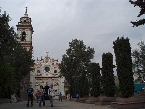
Chicoloapan is a municipality located within the State of Mexico, approximately 25 kilometers east of Mexico City. It is part of the Mexico City metropolitan area and is well-known for its strategic location, which allows for easy access to urban centers, major highways, and public transportation networks. The municipality covers an area of around 80 square kilometers and is characterized by its predominantly urban landscape, with various neighborhoods and communities that house a diverse population. The city's name, which translates to "place of the pine trees," reflects the region's historical significance and its connection to natural resources.
Historically, Chicoloapan has roots that trace back to pre-Hispanic times, with evidence of settlements in the area during the ancient Mesoamerican period. The arrival of Spanish colonizers led to significant changes in the demographics and culture of the area, which became part of the Spanish colonial empire. In modern times, Chicoloapan has evolved from a rural area into a bustling urban center, driven largely by migration from other parts of Mexico seeking employment and better living conditions. The municipality has experienced rapid population growth, which has spurred developments in housing, education, and infrastructure. As of recent estimates, Chicoloapan has a population of over 150,000 residents, reflecting its role as a growing center within the metropolitan landscape of Greater Mexico City.
Chicoloapan is known for its cultural and recreational offerings, including local festivals that celebrate Mexican traditions, such as the Day of the Dead and Independence Day. The area is home to various public parks, community centers, and religious sites, including the notable parish dedicated to Our Lady of the Assumption, which serves as a focal point for local religious life. Furthermore, the municipality's economy is supported by both commerce and service industries, with many inhabitants commuting to nearby urban centers for work. Despite facing challenges typical of rapidly urbanizing areas, such as inadequate infrastructure and public services, Chicoloapan continues to develop as a vibrant community, balancing the growth of urban life with its historical and cultural roots.
Facts about Chicoloapan
- Chicoloapan is located in the State of Mexico, just east of Mexico City, making it a vital location for commuters.
- The municipality is known for its historical significance during the Mexican Revolution, with several revolutionary figures having connections to the area.
- Chicoloapan hosts the impressive Church of San Juan Bautista, a colonial-era structure that is one of the key architectural landmarks in the region.
- The area is characterized by a mix of urban and rural environments, including agricultural lands that contribute to local farming economies.
- Chicoloapan was officially designated as a municipality in 1824, establishing its local governance structure.
- Each year, the municipality celebrates the Feast of San Juan Bautista with processions and festivities that attract visitors from surrounding areas.
- Chicoloapan is also known for its cultural heritage, with various local traditions and crafts that reflect its indigenous roots.
- The town has seen significant population growth and urban development, distinguishing it from many rural municipalities in Mexico.
- Chicoloapan has been actively involved in community development projects aimed at improving local infrastructure and living conditions.
- The region is not only a residential area but also serves as a center for trade activities that connect it to the larger metropolitan area of Mexico City.